In an earlier post, I explained the idea of how young people around the world could collaborate to save the rainforests, inititally in Indonesia, using satellite monitoring.
On July 27th, the genius team at Geodan, lead by Dr.Eduardo Dias, will join Dr. Willie Smits, Dr. Cathy Henkel and young people from around the world for the launch of the technology that will make this dream a reality. If you want to join the live webcast of the launch, register here! It will be fantastic for teachers, students and anyone who cares about the future of the planet.
The following explanation and outline of this ground breaking software is a re-post from Dr.Eduardo Dias’ personal blog.
———————————————
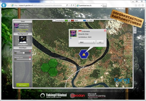
DeforestAction EarthWatchers: Empowering world citizens in tropical forest monitoring via the integration of Earth Observation, social media, human computation and collaborative intelligence.
DeforestACTION is a global project that brings together young people across the planet with the goal of stopping deforestation in Borneo and protecting the habitat of wild Orangutans. Join us at www.deforestaction.org
Among other objectives, students will be able to monitor rain forests via specially designed (web)tools and satellite imagery to provide near real-time intelligence required to halt illegal deforestation. The project will start as a pilot in the province of Sintang, West Kalimantan (Borneo Indonesia), where agreements are established with the local community chiefs and the governor who support this project and offered their executive power to take ground action in stopping illegal activities.
Threaten high-value pristine forest in Borneo was split into millions of unique small cells, and each cell can be allocated to unique participants (youngsters all over the world called EarthWatchers) who monitor it as new satellite imagery becomes available. When they suspect changes/cuts in the forest they will report it in the web system and, operating in a crowd-sourcing approach using social media Facebook , all participants can confirm/dis-confirm. The most suspected areas will be visited by a special team on the ground to prove the suspected activities, report back to the EarthWatchers and involve the local executive power to stop the illegal activities.
This project is unique as it is the first to involve human computation and collective intelligence in the analysis of SAR imagery: while optical data can easily be understood by untrained users (our target group), especially true for “true color” and “natural color composites, the same ease-of-understanding is not usually a characteristic applied to SAR data, where specific expert knowledge and sophisticated processing techniques are needed to derive useful information. Nevertheless, we propose to use the untrained (and unconditioned) spirit of the children (that is free from academic assumptions) to explore the SAR data and we expect that they will uncover patterns and fine issues that might never be uncovered in automated efforts. At the same time, the children will learn about the background technology and potential of SAR earth observation, multiplying the understanding, market and target base of SAR users for the coming 5 to 10 years.
The webgis is also meant as a powerful classroom support tool, as it will make available and accessible many other GIS layers (infrastructure, DEM, oil Palm plantations, biodiversity indexes, socio-economic factors) so that the students not only watch the land, but actually understand the inter-relationships that are playing a role in deforestation. Negotiations are ongoing with education ministries (e.g. Australia, Indonesia, the Netherlands) to make this tool and materials part of the standard curricula.

